
EDINA is holding a celebratory event to mark the 10th anniversary of the launch of the Digimap service on the 20th January 2010. All Digimap site reps and support staff are invited to join us in Edinburgh to mark the occasion.
During the day, there will be a number of speakers and demonstrations to showcase the Digimap service past, present and future and in the evening there will be a drinks reception followed by dinner with guest speaker, Mike Parker (television presenter and author of 'Map Addict').
The daytime event will be free of charge with lunch and refreshments provided. Tickets for the evening event (including drinks reception) will be available for £24 (or £30 including wine).
Site reps and Support staff can find out more details and register for the event here:
Event Programme
#digimap10
Tuesday 8 December 2009
Digimap 10th Anniversary Celebration
Friday 30 October 2009
Live Webinar: Productivity Suite
ESRI (UK) is running a LIVE WEBINAR entitled:
It is being held on Wednesday 4 November 2009, 10:00 – 11:00 am
If you are using Ordnance Survey data from Digimap and your institution has a licence to use ArcGIS, you might find this a useful event to attend. Licensing ArcGIS via Chest includes the Productivity Suite, an additional software application providing data conversion tools. Productivity Suite does not cost extra, but should be requested specifically when the Chest licence is purchased.
Further details of the Webinar can be found on the ESRI (UK) website at: http://www.esriuk.com/trainingevents/events/productivitysuite041109/
Thursday 8 October 2009
A further note on creating EPS files...
You can create EPS files directly from Adobe Acrobat by using an appropriate Printer Driver e.g. CutePDF or one downloaded from Adobe's website. For example: http://www.adobe.com/support/downloads/detail.jsp?ftpID=1500 and follow the instructions at: http://www.ep.ph.bham.ac.uk/general/printing/winsetup.html
Note: you will need the Generic Colour Postscript PPD file linked in the document if you want to print A3 or larger. You can download the PDD file from the above website.
Load the PDF into Acrobat and then go to File ->Print. Select CutePDF Writer (or another Postscript printer you have installed). Click on Properties and then the Advanced... button.
There is a section called Postscript Options; expand this to find the PostScript Output Option and change this from 'Optimize for Speed' to 'Encapsulated Postscript (EPS)'.
When you print you will now be asked to save a file which you should add the extension .eps to your file. You should be able to open this file in Ghostview as a vector EPS.
Wednesday 7 October 2009
In lieu of EPS files...
Since Digimap ceased to generate EPS files we have had a number of enquiries about suitable alternatives. Currently, Digimap's mapping facilities will only produce PDF files. However, there are a number of options for those who prefer to use other formats. The following notes may help.
Note that EDINA does not endorse or recommend any of the products or services detailed here or guarantee their quality or performance.
PDF files generated from Digimap can be converted to various other formats including PNG, SVG, and PS/EPS using free software called Inkscape (http://www.inkscape.org/). The only down side to this that we have found is that it seems to blur the PS/EPS because of the 'Digimap' watermark.
You can also edit the vectors in Inkscape. If you want to put the map (or a bit of it) into a Word document there is a nifty little command in Acrobat under Tools --> Select & Zoom--> Snapshot Tool which allows you to define an area and then paste it into Word (or another programme) - note this is lower resolution than you can create with Inkscape.
The PDFs themselves can be opened in CS3 Adobe Illustrator as editable vector graphics and then exported to various formats. The PDFs can also be opened and converted to EPS in GhostView but this seems to treat them as images rather than vectors.
There are various software packages that will convert from vector PDF to DXF (e.g. http://www.trixsystems.com/pdfFLY.html) but we have not found any which are free of charge.
If DXF/DWG is required for OS MasterMap, the best option is to download GML and use Dotted Eyes' InterpOSe software to convert from GML to DXF/DWG.
Monday 5 October 2009
Roam - new mapping tool available
Today, Monday 5 October, a new mapping tool is available to all registered users, through Digimap's Ordnance Survey Collection.
Roam, the new mapping facility, is available as a BETA service and will therefore be subject to various improvements over the next few months. Planned changes include:
- additional print formats as alternatives to PDF
- inclusion of scalebar on printed maps
- provision of scale and extent indication on screen maps
- adding a "My Maps" function for bookmarking maps
Roam offers "click and drag" functions to locate your map, 12 map views at different scales, printing in PDF at both A3 and A4 sizes, search by place name, postcode or grid reference, seamless scrolling through the fixed scale maps and 5 customisable map views. You can access Roam from the icon above Classic in Digimap's Ordnance Survey Collection home page.
We hope you will use the new facility and let us know what you think of it. There is a link within Roam for you to report any feedback you have (positive and negative). You can also email us on edina@ed.ac.uk or telephone us on 0131 650 3302.
Roam will replace the current Classic facility in January 2010.
Tuesday 29 September 2009
New Digimap Training Schedule 2009-10
Booking is now open for several Digimap training courses and online workshops to be run in 2009-10. These events are open to staff members in UK higher and further education institutions.
Further details of course content and learning objectives can be found on our website, where you will also find booking forms: http://edina.ac.uk/events/
The first online workshop, Digimap Site Reps - Update for 09/10, is scheduled for 7 October 2009 at 12:00 noon. Emma Sutton will discuss the Variation Agreement to the Ordnance Survey Data sub-licence, which took effect in August 2009. The recent data update will also be covered.
Lunch and refreshments are provided for attendees. All EDINA training courses are free of charge. Regretfully, however, we will charge £25.00 per person for each day of absence of which EDINA is not given prior notice.
If you are uncertain about the relevance of a course for your needs, please get in touch with EDINA for advice at edina@ed.ac.uk.
Friday 25 September 2009
MasterMap Download: availability update
Following an unscheduled outage over the past 24 hours, MasterMap Download is now available again.
However, Topographic Layer orders are limited to 25sq.km and all orders may take longer than the advertised 2 days to process. Please be patient and do not resubmit your order.
We aim to restore full service early next week. Further information will be posted here when available. Apologies for the inconvenience.
Thursday 24 September 2009
MasterMap Download unavailable
Following some unsuccessful remedial work carried out on the database this morning, MasterMap Download continues to be unavailable.
At this time we do not know when the service might be restored. Engineers are working towards this, but a time estimate is not yet available.
Further information will be posted here when available. Apologies for the inconvenience caused.
Wednesday 23 September 2009
MasterMap Download now available
Following this afternoon's diagnostics test, MasterMap Download is now available but running under reduced capacity. Orders for Topography Layer are limited to 5 x 5 km (25 sq. km) as a temporary measure.
Between 07.30 and 09.30 hrs on Thursday 24 September, MasterMap Download will be unavailable to allow a fix to be applied. Further information on its success will be available thereafter.
Apologies for the inconvenience caused.
MasterMap Download temporarily withdrawn: 23.9.09
The MasterMap Download facility will be temporarily withdrawn at 14.00 hours today, Wednesday 23 September 2009.
Currently, significant software faults are causing most data orders to fail and the system is unstable. Withdrawing access will allow EDINA to undertake diagnostic work to identify a solution to the problem. External software suppliers are also involved.
As yet, we do not know how long the service will need to be unavailable, but futher information will be posted here and on the Digimap login page, as and when it is available.
Should you have an urgent data order, please contact the EDINA Helpdesk with details of the data you require. We cannot process orders immediately, but we may still have an opportunity to meet the advertised 2-day delivery schedule. This very much depends on the problem identified.
EDINA apologises for any inconvenience caused.
Tuesday 22 September 2009
2009 Annual Data Update
On Thursday 17th September EDINA released all available updates for data provided through Digimap's Ordnance Survey Collection. Details of the versions of all the data offered can be found on the EDINA website here. The Digimap licence also now offers MiniScale and the OS 1:250,000 scale colour raster data. These are currently available through ShareGeo and will be added to the Data Download as soon as possible.
Friday 4 September 2009
Reminder: OS Collection Licence Renewal
Remember that you need to renew your institution's subscription to Digimap's Ordnance Survey Collection BEFORE 30 September 2009 in order to ensure continuity of service.
If your institution has not completed and returned the appropriate licensing forms by this date, access to Digimap's Ordnance Survey Collection will be removed.
Owing to the way access is controlled under the UK Federation there will be no exceptions to and no leeway given for this date. If you have already requested an invoice, you still need to return the subscription forms to the address supplied on the forms by 30 September 2009.
Should you have any questions please contact either JISC's Subscription Agent (subscriptionshelp@jisc.ac.uk) or the EDINA Helpdesk (edina@ed.ac.uk)
Tuesday 18 August 2009
CHEST / ESRI Technical Event - 15 Sep 2009
The following event may be of interest to Digimap users.
Following the success of the ESRI Technical Event held at the University of Leeds in 2008, Eduserv and ESRI have arranged a second meeting, to be held at the University of Birmingham on 15th September 2009. The meeting is intended to bring together people from universities and colleges who are either using ArcGIS (or other ESRI software) or providing and supporting ESRI software in their institutions. In addition to an overview of the new facilities in the latest version of ArcGIS, other topics include a visit to Birmingham University's 3-D Visualisation Suite, a discussion of how to make the most of the ArcGIS licence management system and an introduction to ArcGIS in virtualised or server environments. There is also plenty of time to meet and talk with colleagues from other institutions and staff from ESRI UK.
Lunch will be provided and there is no charge for the event. However, you do need to register your interest in attending. You can do this online at MyESRIUK here:
- Registration Page (go to CHEST Seminar on 15th September)
Date: Tuesday 15 September 2009
Time: 10:00am tea and coffee for a 10:30am start
Location: University of Birmingham (specific details and map will be provided upon registration)
Timetable:
10:00am - tea and coffee
10:30am - ESRI Introduction: Angela Baker (ESRI UK)
10:50am - Virtualisation vs. ArcGIS Server: Peter Halls (University of York) and Alison Rumble (ESRI UK)
11.20am - User Experience Talk
12.00pm - 2.00pm - Lunch with time for networking as well as guided
tours of the Virtualisation Suite at University of Birmingham
2.00pm - Interoperable Landmap and EDINA data and services: Kamie Kitmitto (Mimas)
2:30pm - new features of ArcGIS 9.3.1 and extensions - demonstration by Alison
Rumble (ESRI UK)
3:00pm - Break for tea and coffee
3:30pm - Licensing Issues: Anna Clough (University of Leeds) and Peter
Halls (University of York). Topics include: how to find out how many
users you really have and who those users are (flex logfile analysis);
non-dongled support; use outside of the British Isles; licence servers.
4:00pm - Question and Answer
4:30pm - Tea / Coffee to close.
For full details of the Chest Agreement for ESRI please visit www.eduserv.org.uk/ESRI
If you have any questions, please see the Eduserv website or contact Eduserv Help at help@eduserv.org.uk
Friday 7 August 2009
Ordnance Survey Licence Renewal
On 1 August 2009, the Ordnance Survey Data Sub-Licence Agreement was extended and amended by a Variation Agreement. If institutions wish to continue their subscription to Digimap's Ordnance Survey Collection, the Variation Agreement must be signed and returned by Wednesday 30 September 2009. Institutions not submitting renewal forms by this date will have access to the service removed. There will be no exceptions to this. Details of how to re-subscribe are given on the JISC Collections website.
When an institution re-subscribes to Digimap's Ordnance Survey Collection, it agrees to the terms of the Ordnance Survey Data Sub-Licence Agreement AND the Variation Agreement. Some of the clauses in the Sub-Licence Agreement are superseded by those in the Variation Agreement. Both documents must be read in conjunction with one another, since one is not valid without the other.
EDINA has drawn up a set of Frequently Asked Questions to help you understand what the the Sub-Licence and Variation Agreements will permit in terms of map and data usage. These can be found at: http://edina.ac.uk/digimap/support/faq_oslicence.html
The following is a summary of the changes which are brought into effect on 1 August 2009 by the Variation Agreement. The original Sub-Licence Agreement holds good unless it has been amended by the Variation Agreement. Please read the Variation Agreement itself for full details of the amendments.
- The definition of Authorised User has changed. An individual must fulfill three conditions in order to be an Authorised User. Individuals must:
- be a student of, staff (both current or retired) of, or visitor to an Authorised Institution
- be authorised by an Authorised Institution to access the Authorised Institution's electronic information services via secure authentication; and
- be registered with EDINA Digimap
Overseas Students are also specifically excluded from being Authorised Users, unless they are resident within the UK. Check the wording of the Variation Agreement carefully. Note also that it is the institution's responsibility to ensure that students who are not eligible for access to this service are not given the means to access it. Under the UK Federation, EDINA is not able to check eligibility. - All references to Athens have been superseded by references to the UK Access Management Federation.
- Class Registration is no longer possible. This has been the case since the introduction of the UK Access Management Federation in August 2008, but has now been formalised in this Variation Agreement. Assigning one username to more than one individual (as per a Class registrations) is not permitted under UK Federation policy.
- Authorised Users are now explicitly permitted to share data with other Authorised Users, either in the same or another Authorised Institution. This was previously implicit, but has now been made explicit. Sharing data between Authorised Institutions is still subject to completion of the Transfer of Data form as specified in the original Sub-Licence Agreement (Schedule 7, section 8.1)
- The Permissible Publication Sizes have been amended. These now offer a significant improvement on the previous restrictions to the size of maps published. For example, it is now possible to publish a map of Great Britain in electronic format. Please read Schedule 2 of the Variation Agreement for specific details of the new rules.
- Two new datasets have been included in the agreement: MiniScale® and the 1:250,000 Scale Colour Raster. A full list of products available can be found on the EDINA website.
Both the Sub-Licence Agreement and the Variation Agreement are available from EDINA's website:
Questions regarding the subscription process and the licence agreements should be directed at JISC Collections. Questions relating to the Digimap service should be directed at the EDINA Helpdesk.
Monday 27 July 2009
Wednesday 22 July 2009
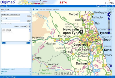
New facility, new name
As indicated in a previous post, EDINA is creating a new version of the existing Classic mapping facility. A sneaky peek at the new interface under development....
Given that the new facility works in a very different way, we would like to give it a new name. We have a number of suggestions, and would like to know your views on them. To this end, we have posted a poll on this blog (look to the top right hand side of this window) for you to vote with.
There are a number of things we need to take into account in choosing a name. For example:
1. It needs to give the mapping facility an identity. When users contact our helpdesk asking for assistance with it, they need to be able to refer to it by name with confidence that we will know what they are referring to. Similarly, our helpdesk need to be confident that they understand which facility a user is talking about, and using an easily identifiable and catchy name for it is an easy means to that end.
2. It needs to be memorable - users need to know which facility they are using.
3. It needs to be unique, not used by any other mapping organisation for a mapping service or product.
Vote on the blog here, or if you would rather, send us an email with your ideas. Thanks for your help!
Wednesday 17 June 2009
ShareGeo for Sharing Data
Have you created geospatial data for your research project or teaching module?
If so, why not put it in ShareGeo and share it with other Digimap users?
ShareGeo is a facility in Digimap where users can share and re-use geospatial data, whether they have been derived from exiting Digimap data or created entirely from scratch.
Why should I put my data in ShareGeo?
- increase the visibility of your research
- share datasets easily with colleagues and peers
- create a record of your data with simple metadata
- manage your data for future use
- find datasets you may be interested in
- save time by re-using existing data that others have created
New datasets available in ShareGeo include: UK Digital Terrain Model (DEM), UK National Parks boundaries, Government Office Regions, Strategic Health Authority boundaries and many others.
A full list of all datasets in ShareGeo can be found here.
How do I access ShareGeo?
ShareGeo can be accessed by logging in to Digimap and following the link on the Collections page to ShareGeo. http://edina.ac.uk/digimap/
More information about ShareGeo can be found at: http://edina.ac.uk/projects/sharegeo/index.shtml
Let us know what you think about ShareGeo by sending an email to: mailto:edina@ed.ac.uk?subject=ShareGeo
Monday 8 June 2009
Forthcoming changes to Digimap
The current version of Digimap's Classic facility (available through the Ordnance Survey Collection) is currently undergoing both a facelift and some reconstruction work!

EDINA will operate both new and existing versions of this facility in parallel to ensure that a smooth transition is made between them. If you have teaching materials or help pages which are currently based on the existing version, there will be plenty of time to update them before the existing version of Classic is withdrawn.
Survey for Support Staff
EDINA is undertaking a survey to understand more about support for online geospatial resources, spatial data, GIS and related software. We would like to learn more about what support and training is currently available, what is useful and what might be provided to improve the support available.
If you have any kind of support role with respect to spatial data, GIS, CAD or geospatial resources we would be grateful if you would complete the following survey and would pass it on to others who are also involved in supporting users of all things geospatial.
The survey link is here: http://tinyurl.com/geosupportsurvey
The survey will remain open and available until TUESDAY 23 JUNE 2009.
This is NOT a service-specific survey, so anyone involved in supporting users of geospatial data and resources has something valuable to contribute. Please pass it on. Gathering feedback is a challenging task, so your efforts to complete these questions is very much appreciated.
The survey should take around 20 minutes to complete and the majority of questions are multiple choice checkboxes. There will be a prize draw for four £25 Amazon vouchers. Please enter your name and email address at the end of the survey if you wish to be entered into the draw.
Many thanks for your time.
Wednesday 3 June 2009
What do you know about postcodes?
There is a lot to know about UK postcodes! Here are some interesting key facts:
- There are around 2 million postcodes in the UK, covering something like 29 million addresses.
- A postcode is made up of four constituent parts. Take the postcode EH9 1PR as an example:
- The postcode Area is indicated by the initial one or two letters: EH
- The post District is indicated by the one or two numbers following the Area: EH9
- The postcode Sector is indicated by the number after the District: EH9 1
- The postcode Unit is indicated by the full postcode: EH9 1PR
- Some buildings can contain delivery addresses with different postcodes. High-rise residential buildings are a good example of these. As far as the Code-Point dataset is concerned these are called Vertical Streets, and their boundaries are recorded as regular squares. These are clearly visible when the postcode boundaries are mapped.
- Usually postcodes cover around 15 delivery addresses, although this isn't a hard and fast rule.
- Some postcodes apply to only one address or building. Ordnance Survey's postcode is SO16 4GU. Buckingham Palace also has it's own postcode, SW1A 1AA, and 10 Downing Street's postcode is SW1A 2AA. The House of Commons is SW1A 0AA
- Postcode unit boundaries (which form the OS Code-Point Polygons dataset) are mathematically calculated around a centroid and are not based on physical boundaries visible on the ground. This centroid is calculated using the coordinates for the delivery points in each postcode. These are not necessarily the precise geographic coordinats of the letterbox in your front door!
- The Code-Point dataset offered through Digimap provides much more information than just the postcode and the coordinates of it's centroid. Additional information includes the NHS Region code, Ward name, how many delivery addresses are in that postcode, how many of those are domestic or business delivery points. The range of information given is different for Scotland from England and Wales.
- These enable you to link additional information to the postcode if it is already associated with a code common to the postcode dataset e.g. you can identify which postcodes are associated with data you have collected using Ward codes.
- You can use Digimap's Postcode Query facility (in the Ordnance Survey Collection) to look up the additional information about a particular postcode.
- You can use Digimap's Boundary Download facility to download the Code-Point data and the associated polygons.
Monday 25 May 2009
Reminder: Service Maintenance 26 May
This is a reminder that all Digimap Collections will be unavailable between 17.30 and 20.00 hours on Tuesday 26 May. This is for essential service maintenance.
A further reminder: if you register for Digimap after 5 pm tonight, Monday 25 May, your registration will not be processed until the night of Wednesday 27 May.
Thursday 7 May 2009
Digimap and Licence Numbers
I’ve been asked to provide my institution’s “Digimap Licence Number”. Where do I find this?
There is no such thing as a “Digimap Licence Number”. If you need a specific licence number, we would suggest the OS Educational Copyright Licence number is the most appropriate one to use.
This licence is arranged directly between the institution and Ordnance Survey and therefore doesn’t relate to Digimap specifically. Institutions can hold an OS Educational Copyright Licence without having a subscription to Digimap, although the licence is required in order to take out a subscription to Digimap.
A copy of the licence (on which you will find the licence number) is held by your institution and the licence number is submitted with your institution’s Digimap subscription forms, which are sent to JISC Collection’s subscription agent. Ordnance Survey will also have a record of it.
Wednesday 6 May 2009
Service maintenance - registration delay
EDINA is undertaking some service maintenance on Tuesday 26 May, as previously advertised.
If you are registering for Digimap between 5pm on Monday 25 May and 9am on Wednesday 27 May 2009, your registration will not be processed until the evening of Wednesday 27 May 2009.
This means you will not be able to access Digimap until the morning of 28 May 2009. Applications received on Wednesday 27 May will be processed as usual that night.
EDINA is undertaking significant work on the databases underlying Digimap, and as a result, registration applications will be collected but not processed while this work takes place.
Monday 4 May 2009
Reminder: Digimap Training in June
EDINA would like to remind you that booking is now open and there are spaces available on the following Digimap training courses, which are open to staff members in UK higher and further education institutions:
- Digimap Essentials 4 June 2009, Bilborough College, Nottingham
- Digimap Collections Training 9-11 June 2009, Exeter University
You will find more details of course content and booking forms on EDINA's Training and Events page. If you are uncertain about the relevance of a course for your needs, please contact EDINA for advice at edina-training@ed.ac.uk.
All EDINA training courses are free of charge and lunch is provided. Regretfully, however, we will charge £25.00 for each day of absence from a course without giving us advance notice.
Friday 1 May 2009
Supporting you remotely
EDINA's User Support team has recently delivered some short online workshops about elements of various EDINA services, including Digimap, using a web conferencing service called Instant Presenter. In order to join in with online training, you just need a web browser and a set of headphones.
We plan to develop a fuller programme of such online workshops in the next academic year. Although our initial aim is to deliver these workshops to staff in order to allow them to support users, in time we may open the workshops to students too. You can subscribe to our Training and Events feed so you can be the first to know about forthcoming training dates.
We would really like to hear from you about your requirements. Are there particular elements of our services on which you need more information? Do you have any particular topics of interest?
Ad-hoc online workshops can also be arranged at a time that suits you, so if you need support, please ask! You can contact us via the EDINA Helpdesk or you can call our Training Officer, Vivienne Carr, on 0131 651 1852.
Monday 27 April 2009
Updated Digimap Training Materials
We have recently updated all the training materials available via the Site Representative Support Area within Digimap's Ordnance Survey Collection. To access these materials, log in to Digimap's Ordnance Survey Collection and click on the the Site Representative Support Area link in the left menu panel. Once in the Site Representative Support Area use the index on the left to click first on the Training Materials item, then the Download Materials item.
You are free to take any of the documents to either brush up your own Digimap knowledge and skills or to pass these on to others. Materials can also be downloaded from the EDINA website without logging in to Digimap.
As always Site Representatives are encouraged to use these training materials to run their own local courses on Digimap, both for other staff and for students.
For details of scheduled courses run by EDINA, please visit our Training and Events page. Details of our new online training sessions are also available from here.
Friday 24 April 2009
FAQs about Change-only Update
Why does my Order say that CoU is not available?
Check the date on which you created the original Order. If you created it after the last set of CoU was released but before the next set of CoU is released, then you already have the latest version of the data. If a release of CoU is imminent, you should wait until after the release date, and then check your data order for the availability of CoU.
I have downloaded CoU for my area, but having applied it to my existing data holding, nothing looks different. Why is this?
Not every feature changes every time a Change-only Update is released. It may be that none of the features in your data holding have been updated this time. It is not possible for EDINA to determine exactly whose orders contain changed features.
You may also find that there are some small changes to the attributes for your data. These are harder to identify if you are simply looking for changes visible on a map. It isn't necessarily the geometry or position of a feature which has changed. When you plot the changes on a map, you may not see them, because the changes may relate to data in the attribue table.
Why can't I have CoU for other datasets?
Only OS MasterMap data offers Change-only Update. This is because other datasets are not structured in a way which enables CoU to be identified and extracted separately. Other datasets are also not updated so frequently.
Thursday 23 April 2009
Service maintenance - 26 May 2009
EDINA will be making use of the advertised 'at risk' period on Tuesday 26 May 2009, in order to carry out essential database updates. All Digimap Collections will be unavailable between 17.30 and 20.00 on this day.
EDINA will endeavour to restore full access to all facilities as soon as possible, but given that it is not possible to predict exactly how long the task in hand will take, you should anticipate that the service will be unavailable for the full period advertised above. Notices to this effect will be posted on the Digimap login page.
Wednesday 22 April 2009
Emails sent in error
On Tuesday 21 April, some Digimap users may have received email from EDINA entitled "Activating os registration".
These emails were sent in error and have no bearing on the status of a user's Digimap registration. Please ignore the email and accept EDINA's apologies for any confusion caused.
Monday 6 April 2009
Ordnance Survey Licence Agreement Renewal
Lorraine Estelle, CEO of JISC Collections, has issued the following as an email to all institutions subscribing to Digimap's Ordnance Survey Collection. EDINA will also be distributing this information to site representatives and other support staff.
The current Ordnance Survey Licence Agreement for Digimap ends on 31st July 2009. Ordnance Survey and JISC Collections are working on the renewal of licence which will cover the period from 1st August 2009 to 31st July 2014.
Although the new Licence Agreement is not yet available from the JISC Collections' website, the subscription fees for first year of the new Agreement from 1st August 2009 to 31st July 2010 are confirmed: in light of the current economic situation the subscription fees for this period will remain at the current level, with no retail price index increase.
JISC Collections will be consulting with users about a new subscription model from 1st August 2010, which it hopes will enable more institutions to afford the other datasets available from the Digimap Collections: Historic Digimap, Marine Digimap and Geology Digimap. The consultation will commence in the autumn of this year.
Given that the pricing model for 1st August 2010 to 31st July 2014 is uncertain until the consultatation is complete, institutions signing the new Licence Agreement for 1st August 2009 31st July 2014, may opt-out at 31st July 2010 if they need to.
Friday 3 April 2009
Digimap Essential Maintenance: 7 & 14 April 2009
On Tuesday 7 April 2009, EDINA will be undertaking essential maintenance on the servers which run Digimap. In order to minimise disruption to the service, there will be two short periods of downtime on this day (rather than a single long period of downtime).
These periods of downtime will be between 08:00 - 08:45 AND 17:30 - 20:00. All Digimap Collections will be unavailable during these times.
EDINA will also be making use of the normal 'at risk' period on Tuesday 14 April 2009, to carry out further essential maintenance. All Digimap Collections will be unavailable between 17:30 and 18:30. We will endeavour to restore full access to all services as soon as possible, but given that it is not possible to predict exactly how long the task in hand will take, you should anticipate that the service will be unavailable for the full periods stated above. Notices to this effect will be posted on the Digimap login page and a reminder will be sent to site representatives.
Monday 30 March 2009
AGILE Initiative - Spatial Data Access Survey
Higher and Further Education in the UK already has access to a significant quantity of mapping and spatial data from Ordnance Survey via the Digimap agreement. EDINA is conducting a survey in order to understand more about current academic access to maps and data from other national mapping agencies (i.e. the European equivalents of Ordnance Survey) in other European countries. While we are happy for Digimap users to complete the survey, you can help us further by passing this link on to friends and colleagues within Higher or Further Education elsewhere in Europe: http://tinyurl.com/NMCAUserSurvey Please read on for more details.
*****
Are you are a teacher, lecturer or researcher at a Higher Education Institution in Europe?
Do you use geospatial data (maps, aerial photography, satellite imagery etc.)?
http://tinyurl.com/NMCAUserSurvey
What is the purpose of this survey?
The purpose of this survey is to find out how easy it is for you, as a teacher or researcher, to gain access to the geospatial data sets held by the National Mapping and Cadastral Agency or Agencies in your country. Europe’s Network of National Mapping and Cadastral Agencies (NMCAs) hold and maintain the majority of Europe’s ‘core’ geospatial information including:
- topographic data;
- cadastral information;
- aerial photography; and
- land use information and historical map data.
We believe that Higher Education in Europe should be an important market for the NMCAs, as there are around 4,000 Higher Education institutions, with over 17 million students and 1.5 million staff.
With your help, we hope to find out how easy it is to access these data. We will use this information to encourage more NMCAs to make their data available to teachers and researchers in Higher Education across Europe. Our goal is to help you gain access to the quality geospatial data that you need.
Who is carrying out the survey?
Our research team is part of the EDINA National Data Centre, based in the University of Edinburgh, UK. The survey has been endorsed by the Association of Geographic Information Laboratories for Europe (AGILE) and EuroGeographics, which represents 52 National Mapping and Cadastral Agencies from 43 countries across Europe.
When will the survey finish?
The survey will be open for you to complete until Tuesday 21st April 2009.
During this time we would like your help to get as many teachers and researchers as possible to complete the survey. So, once you have completed the survey, please pass on the email and web link to this survey.
How do I complete the survey?
The survey can be found at http://tinyurl.com/NMCAUserSurvey
Who should I contact for more information?
If you have any questions please contact: Dr David Medyckyj-Scott, by email at edina.surveys@ed.ac.uk
Friday 20 March 2009
Reminder: April Digimap Training
This is a reminder that there are still spaces available on the following Digimap training courses, open to staff members (and postgraduates for the OS MasterMap courses) in UK higher and further education institutions:
- Digimap Collections: 31 March-2 April 2009 - Leeds University
- OS MasterMap for Users: 22 April 2009 - York University
- Digimap Essentials: 4 June 2009 - Bilborough College, Nottingham
- Digimap Collections: 9-11 June 2009 - Exeter University
Note that all attendees MUST be registered users of Digimap's Ordnance Survey Collection in order to participate in the OS MasterMap training.
Wednesday 18 March 2009
OS MasterMap: CoU release on 24 March
The next release of Change-only Update data for OS MasterMap will be put into service on Tuesday 24 March 2009. The currency date of the new data will be 20 January 2009.*
Change-only Update (CoU) applies only to the OS MasterMap data. It does not apply to any other data product.
EDINA collates all the data changes released by Ordnance Survey over a 6-month period, and makes these available through Digimap approximately every 6 months. The previous update was released in September 2008.
What is the point of Change-only Update?
Change-only Updates enable you to update your data holding without needing to store multiple copies or versions of the same data. By taking only the changes to the data you hold you can minimise the storage requirements for your data, while still maintaining an up-to-date dataset. This is particularly useful if you are studying changes to an area over time.
Most users will not need Change-only Update. CoU is only useful to you if you already have a full copy of the original data to which you can apply the changes.
How do I download CoU?
You can download Change-only Updates only for data orders you have already submitted within Digimap's Mastermap Download facility. Go to the Your Account page within Mastermap Download and scroll down to the table of Orders.

You will see a list of all your previous Orders, and in the final column you will see whether or not CoU is available for that Order.
If CoU is available, click the radio button in the far left column for the Order you require. Below this table, you will see two buttons in a blue box: Click the first button to Order Change-only Update. The data file will be delivered in the usual way: you will receive one email to say your Order has been received and is being processed, and a second email to say your data is ready for collection.
If you submit a new order for OS MasterMap data, by defining the Layer, Themes and your chosen area, you will automatically receive the latest version of the data; this will include all the latest changes. Change-only Update will therefore not be available for such an Order until the next batch of CoU is released.
Example
You submit an Order for data on 20 March 2009. In the Orders table under Your Account, the Order details say that CoU is not available. This is because you already have the latest version of the data.
If you submit a second Order for data on 27 March 2009, you will also see that the order details say that CoU is not available. Again, you have the latest version of the data; it includes the changes which were released on 24 March.
If you go back to look at your first Order (submitted on 20 March) on 2 April 2009, you will see that COU is now vailable for this Order. This is because the changes released on 24 March are now available; they were not available when you submitted the original order.
* Although the latest update is dated 20 January 2009, it takes time for Ordnance Survey to process and release these data, to send them out to EDINA and for EDINA to process and load the data into the database. This accounts for the time delay between the "freeze date" of the database (20 January 2009) and the release date (24 March 2009).
Friday 20 February 2009
Northern Ireland map data: JISC Consultation
JISC Collections has an opportunity to add Ordnance Survey of Northern Ireland (OSNI) data to the Digimap Collections. Before a final decision is made to pursue this agreement JISC Collections would like to guage interest in these mapping data from existing subscribers. JISC Collections would welcome feedback on whether or not your institution would participate in an agreement to supply OSNI data through Digimap Collections.
It has been proposed that the following data be included in the licensing arrangement. The suggested formats are also given for each dataset:
- OSNI Largescale Vector (ntf, dxf, dwg)
- OSNI 1:50,000 Vector (shapefile, mapinfo tab)
- OSNI RegionalMap (pgdb, shapefile)
- OSNI GlobalMap (pgdb, shapefile)
- OSNI Road Network (shapefile, mapinfo tab)
- OSNI Boundary Map (pgdb, shapefile)
- OSNI Pointer Product (format: csv) (Pointer includes Royal Mail Group PAF postcodes)
- OSNI Place Name Gazetteer Product- OSNI 1:10,000 Raster Product (format: tiff, ecw)
- OSNI Raster Activity Map Products (format: tiff, ecw)
- OSNI 1:50,000 Raster Product (format: tiff, ecw)
- OSNI 1:250,000 Raster Product (format: tiff)
- OSNI Parliamentary Constituency Raster Map Products (format: jpeg)
- OSNI Raster Street Map Products (format: tiff, ecw)
- OSNI Historical Archive Product (format: ecw)
- OSNI DTM 50m, standard, enhanced Products (format: txt, dbf, dgn)
- OSNI Orthophotography Product (format: ecw)
The suggested prices for an institutional subscription to this agreement vary according to JISC's institutional banding, and are as follows:
Higher Education
- Bands A-B - £750 per annum
- Bands C-D - £600 per annum
- Bands E-F - £400 per annum
- Bands G-J - £100 per annum
- All bands - £75 per institution
If you would find it useful to have access to Northern Ireland data, please contact your Digimap site representative to express an interest in a subscription. If you don't know who your site representative is, please check the list on our website: http://edina.ac.uk/digimap/list.shtml
If you are a Digimap Site Representative, please gather feedback you receive from Digimap users at your institution and contact Liam Earney (L.Earney@jisc.ac.uk) if you would like to express an interest in a subscription for your institution.
Tuesday 17 February 2009
Training: booking now open
EDINA would like to announce that booking is now open and there are spaces available on the following Digimap training courses, open to staff members (and postgraduates for the MasterMap courses) in UK higher and further education institutions:
- Digimap Collections: 31 March-2 April 2009 - Leeds University
- OS MasterMap for Users: 22 April 2009 - York University
- Digimap Essentials: 4 June 2009 - Bilborough College, Nottingham
- Digimap Collections: 9-11 June 2009 - Exeter University
This page contains details of all forthcoming EDINA courses and workshops which may interest staff within subscribing institutions, including multimedia services courses to be announced soon.
We strongly encourage site representatives to attend an OS MasterMap course if they have not done so already. Other members of staff and postgraduate students from institutions which subscribe to Digimap are also welcome. Note that all attendees MUST be registered users of Digimap's Ordnance Survey Collection in order to participate in the OS MasterMap training.
Running the courses is subject to a sufficient level of interest. If you are uncertain about the relevance of a course for your needs, please get in touch with EDINA for advice at edina-training@ed.ac.uk
All EDINA training courses are free of charge. Regretfully, however, we will charge £25.00 per person for each day of absence of which EDINA is not given prior notice. This is due to the increasing number of no-shows at courses.
Lunch will be provided for all full-day attendees and refreshments will be available throughout the day. If you have any questions about Digimap or these courses, please do not hesitate to contact us.
Wednesday 28 January 2009
ShareGeo Launched
A new geospatial data sharing facility has been released today which enables Digmap users to find and share geospatial datasets.
 Use ShareGeo to contribute your own (derived or user-generated) geospatial datasets, or to download datasets which are already there for your research, teaching or personal use.
 Monday 26 January 2009
Obituary: Peter Burrough
Peter Burrough, one of the founding fathers of GIS research, died in Leiden on 9th January 2009.
Peter Burrough is recognised for his for seminal work, Principles of GIS for land resources management. Published in 1986, the book introduced the essential technical tasks of GIS applications such as spatial data capture, storage, and output, and the development of the analytical models that were needed to exploit the full potential of this new technology. The book became an instrumental resource for soil scientists as well as geographers, surveyors, social scientists, urban planners and students in these fields. As a result many became interested in the newly developing GIS field.
Peter Burrough is also recognised for his important contributions to the creation of both AGILE (the Association of Geographic Information Laboratories for Europe) and to EUROGI (EURopean Umbrella Organisation for Geographic Information) at a critical point in its development.
In January 2007, his role as a founding father of GIS research was internationally recognised in a special issue of the International Journal of Geographic Information Science on Advances in the spatio-temporal modelling of environment and landscapes. This was edited by two of his former colleagues at Utrecht University and the co-author of the second edition of his classic work, Rachael McDonnell.
Tuesday 20 January 2009
NEW! Geospatial data sharing service
EDINA have implemented a new geospatial data sharing facility called ShareGeo. It forms part of the Digimap Collections suite of services. It is intended that ShareGeo will be accessible to all Digimap users at the beginning of February, however we are providing early access to it for readers of the Digimap blog (details of how to access it are below).
Please feel free to browse and download any datasets that are already there. If you have any geospatial datasets, we would ask you to contribute these to ShareGeo. ShareGeo is free to use for all registered Digimap users.
ShareGeo can be accessed after logging in to Digimap, using the following liks.
- First login to Digimap at: http://edina.ac.uk/digimap You will see a greyed out link to ShareGeo.
- The visible link is not active, so you will need to go to ShareGeo by entering the following link in your browser: http://digimap.edina.ac.uk/sharegeo/ (Note: Once the facility is accessible to all, there will be a link on the Digimap Collections page to take you directly to ShareGeo)
If you need help or advice regading ShareGeo please do not hesitate to contact us.
Monday 12 January 2009
12 January - full access restored
Following a hardware failure during routine maintenance, access to all Digimap Collections and facilities has been restored. Apologies for the inconvenience caused by this incident.
Saturday 10 January 2009
10 January - Digimap Now Available
Access to the Digimap service was restored around 7pm last night (Friday 9 January) following a recent hardware failure. However, the MasterMap Download facility remains unavailable and will do so until Monday 12 January.
The available services have not yet been fully tested, so it is possible that you may find some elements not fully functional. If you encounter any failures, please report these to the EDINA Helpdesk on edina@ed.ac.uk; they will be dealt with on Monday 12 January.
Friday 9 January 2009
9 January - update
Following yesterday's scheduled maintenance, Digimap remains unavailable today owing to an unexpected hardware problem which could not have been predicted. Engineers are currently working on some diagnostic tests to establish the extent of the problem.
In diagnosing the problem there are a number of tasks to be performed, each one of which may or may not offer a solution. It is therefore not possible to predict how long it will take to reach a solution.
The full Digimap service will not be available today, Friday 9 January or on the morning of Saturday 10 January. Our next opportunity to provide an update on progress will be around 2pm on Saturday 10 January. Further to that, updates will not be available until Monday 12 January.
Again, EDINA apologises for the inconvenience this causes.
9 January: Digimap unavailable
Yesterday, a significant upgrade was scheduled for the service machines which host Digimap. The upgrade should have been completed by around 5.30 pm. However, unforseen problems with the upgrade have meant that Digimap remains unavailable today, Friday 9 January. Our last update yesterday was at 6.45pm.
Engineers are currently having to acquire and install a new piece of hardware in order to fix the problems which arose yesterday. As yet we do not know how long this will take, nor do we know when the next progress update will be delivered. When we have further information on an estimated time for restoring access to Digimap, this information will be posted here and on the Digimap login page.
EDINA apologises for the inconvenience the service unavailability causes.
Wednesday 7 January 2009
Review of geo-spatial services for the ESRC
EDINA has received the following message regarding a survey being conducted by the Economic and Social Research Council (ESRC), which we believe will be of great interest to you.
EDINA believes that this survey will influence the development and availability of services offering geospatial resources to the academic community. If you or your colleagues make use of, or have in the past made use of, geospatial data or resources (maps, satellite data, statistical data, census information etc), we would strongly urge you to complete the survey.
We would also be grateful if you would pass on a link to this page to colleagues who may not see it. Note the closing date of the survey is 31 January 2009.
The following text is from the researchers conducting the survey, and gives some useful background:
In support of the National Strategy for Data Resources for Research in the Social Sciences, the Economic and Social Research Council has commissioned a review of the current availability of, access to, and future needs for geo-spatial data services by the research community. These are broadly defined and include not only the data necessary to map and analyse data with a spatial dimension, but also resources which broaden the range of spatial research undertaken and enhance the ability of researchers to undertake spatial analysis.
To assist us with this review, would you please spare a few minutes to complete a short web-based survey concerned with the awareness and use of geo-spatial resources by researchers and their opinions about new areas for development via ESRC investment. Please note that we are interested in your opinions even if you are not currently undertaking research with a spatial or geographical dimension.
Any information you provide will be used purely for statistical purposes in order to plan future services. This survey will remain confidential and any published results will not identify individuals.
The survey should take 5 to 10 minutes to complete and will remain openuntil 31 January 2009.
Link to: Geo-Spatial Resources and Services Survey
Many thanks for taking the time to complete this survey.
Peter Elias, Anne Green and David Owen,
Institute for Employment Research,
University of Warwick,
Coventry CV4 7AL.
NB: If you want further information about this review or wish tocontribute your views/opinions in a more detailed fashion, please emailthe researchers directly:
Peter.Elias@warwick.ac.uk
Anne.Green@warwick.ac.uk
D.W.Owen@warwick.ac.uk
Monday 5 January 2009
Reminder: Digimap Training in January
Places are still available for Digimap training in Newcastle on 20 - 22 January 2009. Further details can be found on the EDINA website.
You can register online for this event here.
EDINA would also like to wish you a happy new year.
